

News
MAC9 using DC4 and GeoMM
|
Highways Agency Area MAC9, operated by Amey LG, has become the latest agent to take up both DC4 and GeoMM. They are utilising Nomad hand-held computers to collect the data and can transmit the files to a protected area on the JRCS website directly from these devices. When they log in to their GeoMM management system, the files are automatically downloaded and compiled into works orders for issue to their works section and transfer to their internal works ordering software. All data can be accompanied by OSGR co-ordinates obtained from the in-built GPS receiver and optionally a linked photograph of each defect. These are plotted on their background maps for easy management. |
|

New version of DC4 for Sign Surveys
|
A new version of DC4 was produced specifically to collect sign data. This was requested by PTS Ltd who were undertaking a county-wide survey for a local authority and loading the data into their client’s existing inventory database. JRCS Ltd welcomes suggestions and request for new version of DC4 which potentially can be adapted to collect any type of data. |
|

GeoLight and DC4Light being used by A1M DBFO in North Yorkshire
|
The GeoLight street lighting database has been in operation on the A1M DBFO in North Yorkshire for several months. Current lighting inventory data is exported from GeoLight to data collection units running DC4Light and after each inspection, the collected data is uploaded back to GeoLight for automatic generation of works orders. The electrical items and any recorded defects are shown on background maps of the network to enable their quick and easy management. |
|

6 Agency Areas are now using DC4
|
6 Agency Areas are now using the DC4 range of data collection software for their routine inspections. DC4Inspec for Safety, Non-specialist Detailed and Specialist inspections Now includes defects to record the HA’s Long-Stop Condition Requirements Users running DC4 on Windows (e.g. XP, Vista, Tablet PC) - Attached GPS devices can now be used - The camera can be used depending on your hardware We are also working on improvements that have been suggested by our users and exploring adding a background map to the GPS. |
|

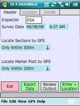
New Location Options in DC4
|
DC4 now has a number of automatic location functions based on the GPS signal it is receiving.
These range from locating the section being surveyed from its start/end co-ordinates through
to locating the nearest inventory item (Marker Post) and estimating the survey chainage.
The chainage accuracy can only be as accurate as the signal being picked up but early indications show it to be generally within 2 meters occasionally going out to 7 meters. For some work this is accurate enough but for other applications other techniques are more appropriate. Whichever way you choose to proceed, we have a solution. Contact us for more details or a discussion of your individual requirements. |
|
5 Agency Areas are now using DC4
|
5 Agency Areas are now using the DC4 range of data collection software for their routine inspections.
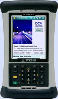
The following versions have been supplied: DC4Inspec for Safety, Non-specialist Detailed and Specialist inspections DC4Invent for Inventory collection and update DC4Light for Lamp Scouting Also available are options for electrical testing, specialist sign surveys and daily safety patrols. All software operates on Windows Mobile 6 devices such as the TDS Nomad (shown to the right) and has options for integrated GPS location and linked Defect Photographs. |
|
DC4 and GeoMM at the 2007 Traffex exhibition
|
John and Stephan attended the 2007 Traffex exhibition at the NEC in April.
Present for all three days as part of the Steanne Solutions stand, the
team was displaying the full range of the DC4 data collection software
and GeoMM data management products.
Also on the stand was the Toughbook roadshow vehicle on loan from Panasonic. Our thanks to everyone who called to see the products and we hope we can do business with you in the near future. |

|
GeoMaintenance Manager in use on Northern Ireland’s motorways
|
Highway Maintenance Management (HMM) has implemented the GeoMaintenance suite of programs
from Steanne Solutions including GeoGrad for data collection, GeoMaintenance Manager for
Inspections and GeoWorks for works ordering and street lighting.
|

|
They are introducing the new technology in stages concentrating initially on Safety Patrols, Lane Availability Monitoring and Safety Inspections and are hoping to introduce the inventory module in the near future when they have some suitable data. All of their procedures from data capture through works completion are map-enabled.
Area 13 go for DC4 solutions three times over
|
Amey Mouchel at Area 13 has used DC4Invent for while and have been so pleased with software
they commissioned a customised version for their Routine Inspections. DC4Inspec has been linked
to a Socket blue-tooth GPS and camera built into their Recon 400 data capture computers so that
the co-ordinates of defects are recorded together with an optional linked photograph of the defect.
The data is output in a format suitable for them to directly load it into their in-house database.
Their Highways Asset Manager, Mark Bulman says ‘We are really pleased with the software. It is far better than we ever expected and easy to use’. They are now embarking on their third application for road lighting, again involving an existing in-house database. |

|